“Our data helps insurers, re-insurers, wholesale brokers and Third-Party Administrators to save  millions in their Underwriting and Claims processes by making their decisions based on objective and reliable data” says Guy Attar, Founder & VP Business Development of GeoX. In a conversation with Insurtech Israel news, he talks about GeoX activity, and the value for the insurance sector.
Describe GeoX’s activity?
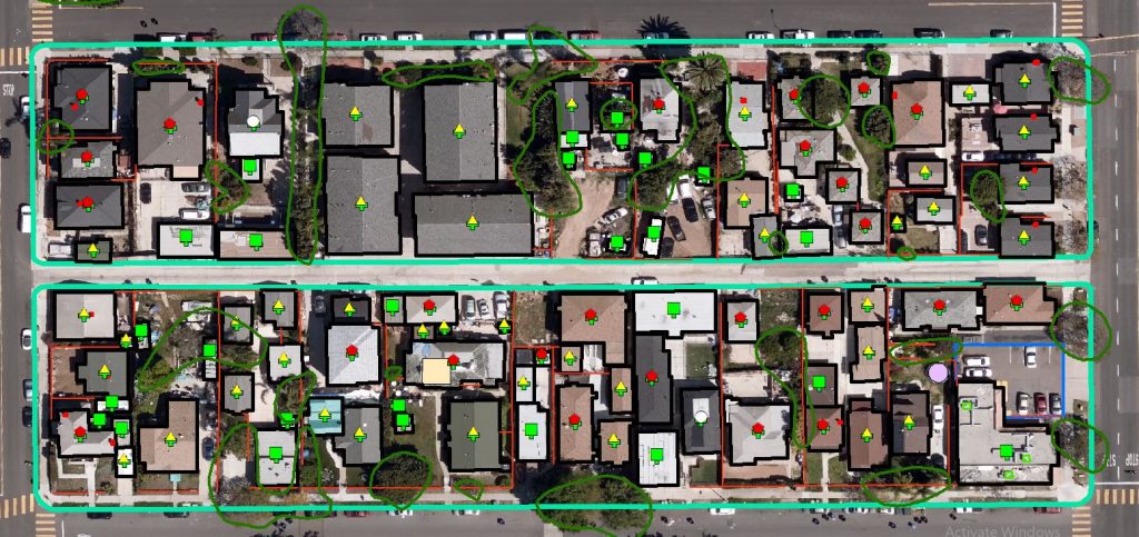
Attar: GeoX is an Aerial Imagery AI analytics company. We produce geospatial Property Data which is used for Underwriting & Claims in the US and European insurance industries. Our unique proposition is in our 3-dimensional extraction technology which provides rich information about every property. For example, the data includes detailed dimensions of a building and its exact roof geometry, the condition and damages related to the roof, the existence of objects on or around the property such as Air conditioners, swimming pools, trampolines, water bodies, fences and many other observations implying risks to the property.
How can such an analysis help insurance companies?
Attar: Our data helps insurers, re-insurers, wholesale brokers and Third-Party Administrators to save millions in their Underwriting and Claims processes by making their decisions based on objective and reliable data.
Let me demonstrate this by several examples: When writing property insurance for a residential building in the US east coast where Hurricanes might cause severe damages to the property, the type and condition of the roof become significant factors to the risk scoring and to the policy price. As an example, our data can indicate that a particular building has Tarp on its roof (Tarp is sheet of strong, waterproof material used to protect damaged structures). In some states this can be a clear criterion for denial of insurance or a good reason to adjust the policy price accordingly.
Liability risks are identified by our data indicating the existence of a swimming pool or a trampoline in the yard.
Property data and geospatial imagery helps inspectors to assess fire risks to commercial properties by specifying the distance to neighboring warehouses or to trees in its vicinity.
GeoX also provides roof geometry and dimensions which helps to evaluate the replacement costs in case of roof related claims. This saves visit time and significantly reduces the loss adjusting costs.
 Not a long time ago you have launched a solution for measuring the damages after natural catastrophes. Please elaborate about it.
Attar: We have collaborated with a large global re-insurer in a solution for insurers to efficiently handle the huge operational challenge of loss adjusting thousands of affected buildings after Hurricanes. By fast processing of aerial imagery captured by airplanes after the hurricane ends , loss adjusters can now use highly valuable data to triage and resolve claims faster, to reduce the amount of losses, and to shorten the time people can return to their fixed homes. This is a very satisfying moment when you understand the positive impact our data provide to help people in their worst moments.
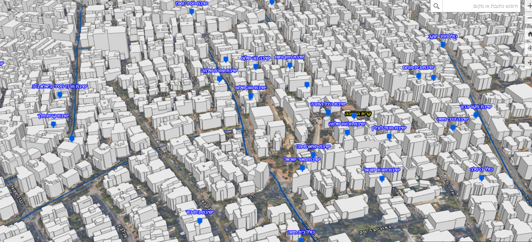
One of the services you have developed is the ability to build a 3D model of entire cities or countries. What can be the value of this service for an insurer?
Attar: We generate 3D building datasets from aerial imagery for complete geographies using automated processes. Our 3D building models are digital representations of the properties, and in conjunction with aerial imagery allows every staff member in any insurance discipline to see the property visualization, and get a good understanding of the structure, its dimensions and characteristics without visiting in the site. It is an excellent tool for making decisions based on fresh imagery showing the reality and facts on the ground.
A relevant note in the interesting times of the Covid19 pandemic: recently , health and public safety authorities requested to use our 3D city models to map and manage, on an individual building level, the operations related to home-quarantined families and the aid actions to elderly citizens in heavily infected cities.
Buildings in the City of Haifa, Israel: https://systematics.maps.arcgis.com/apps/webappviewer3d/index.html?id=04e81a5ee87a4ecaac16ab8cbbfd759f
Building in the City of Bney Brak, Israel: https://systematics.maps.arcgis.com/apps/webappviewer3d/index.html?id=caedfbb16e4b40c1a66014b8d9907b9d
What companies are you currently working with?
Attar: On one hand we work with aerial imagery leaders who provide us access to aerial imagery that covers imagery in most populated areas in USA, Europe , Canada, Australia and some parts in Asia. On the other hand we serve insurance companies that operate in the US , Germany and in the UK.
What investments were made in the company?
Attar: We funded , as founders, a seed investment when we started the company back in mid 2018 and since then we became a bootstrapped business, using our revenues to grow the business. However, we do speak with investors from time to time to explore ways to accelerate our growth even further.
Tell me about yourself and you professional background, and about the founding partners of the company.
Attar: in the last 25 years I’ve held several senior management positions. Prior to GeoX I was heading the Innovation center in Nokia Networks and led the Business development of a Data Services internal startup. Prior to Nokia networks I held the positions of CTO in Seabridge Networks and in Nokia Siemens Networks. After numerous engineering and business achievements in the high-tech industry I have decided to co-found GeoX with my colleague Eli Lavi who worked with me in Nokia Networks and also introduced me to Izik Lavy our co-founder and CEO. My role in GeoX is to lead business development, Marketing and sales.
Izik Lavy is GeoX CEO and co-founder. As an expert in Geographical Information systems, Izik led a technological team in the IDF mapping unit. Izik identified the lack of automation in stereoscopic sampling of imagery, and developed patented algorithms to solve this challenge. I can confidently testify that Izik is an enthusiastic entrepreneur in spirit and in action. By the way, GeoX is his second business endeavor.
Eli Lavy is our CTO and co-founder. In the last 20 years Eli held positions as an experienced software engineer in startups and corporates with deep expertise in ML and cloud computing. Eli is proud of his fast assimilation of new technologies, and of his valuable results in a Machine Learning and Predictive analytics project that he led in Nokia Siemens Networks. before GeoX Eli designed and implemented the software infrastructure of Argus Cyber Security (acquired by Continental). To me, Eli is a wizard in implementing new software technologies!
Every day in work I feel this founding team is a perfect fit of diverse skills and personalities for the GeoX journey. I feel lucky.


